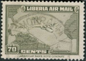
The route to Africa

20 07 2008

Liberia, Scott C43, 1942, 39mm x 24mm

Once again we have a stamp issue commemorating the air supply route from North America via South America to western Africa in the middle of World War II. Only three countries are depicted (the United States, Brazil, and the issuing country of Liberia). An outsized 4-engine transport plane (possibly a C-108 Flying Fortress) is shown alongside the coast-hugging path southward.

I am not sure that the business of transport is considered to have enough charisma to show up much on stamps nowadays, relatives to the most popular topicals.

Previously.


June 25, 1975

1 07 2008

Mozambique independence issue.

Mozambique, Scott 516, 1975, Litho, 22mm x 31mm

One with a red overprint, one without. This issue in an attractive combination of Gray, Light Blue, Blue, Carmine, and Black shows the southeastern African nation of Mozambique, former colony of Portugal. The map shows it all: political boundaries, cities and towns, waterways, neighboring countries, and roadways. These are somewhat obliterated by the overprint proclaming the date of independence and a nicely ornamental flourish.

Independence came in the middle of an extended period of political strife. Even after political reforms came, the country has had trouble developing economically. Some hope, however, to bring the beauty of the long Indian Ocean coastline and the attractions of the country’s wildlife reserves to higher prominence among the international tourist trade.


The rift

24 06 2008

Ascension stamp, Mid-Atlantic rift

Ascension, Scott 268, 1980, 36mm x 48mm

This stamp features two maps, one focusing on the topography of the Mid-Atlantic Ridge, the other on the ancient supercontinent known as Pangaea. Alfred Wegener came up with the theory of continental drift in the early part of the 20th century, long before the subsurface mechanism of tectonic plate motion were worked out. On the main map, the small island of Ascension, nearly unpopulated, appears here right in the middle of the action, slightly to the west of the ridge. Other features appear to the north and south: the archipelago of St. Peter and St. Paul Rocks, St. Helena island, and Tristan da Cunha island, amidst zones of sea floor faulting. On the inset map, of course, Ascension would be pretty much in the fault zone between between what became South America and what became Africa.

The occasion of the issue was the 150th anniversary of the Royal Geographical Society of Britain in 1830.


Holiness

10 05 2008

Burundi stamp with Pope Paul VIBurundi, Scott B39, 1969, 47mm x 29mm
A stamp commemorating Pope Paul VI’s visit to Uganda. The map shows northern and central Africa with Kampala, Uganda, labelled and highlighted with a yellow tinge against the dark green, a dotted line pointing back to the Vatican showing the line of travel. The two countries are not neighbors, but both are located in the east central section of the continent. Several other countries in the area issued commemoratives on this occasion as well.

An inscrption on the stamp indicates this was the first papal visit to sub-Saharan Africa (Paul VI was the first pope to travel on an airplane). He visited the site where a large number of Catholics were martyred during persecutions in the late 19th century, including 22 who were eventually canonized.

Nearly two-thirds of the population of Burundi is Roman Catholic, which used to be a French colony.

At the time this stamp was issued, the current pontiff Benedict XVI was an academic theologian at the University of Regensburg, well before he was to be appointed a bishop or the leader of the Inquisition.


Understated cooperation

4 03 2008

brazil-1402Brazil, Scott 632, 1945, 37mm x 29mm
Here is another World War II commemorative masquerading as something celebrating international trade or something like that.

If one looks very closely at the destinations highlighted on this – Miami, Port [au] Prince, Puerto Rico, Trinidad, Georgetown, Belém, Fortaleza, Natal [Rio Grande do Norte], Ascencion, Accra, Khartoum, and Cairo – tiny little aircraft symbols oriented west to east can be seen. This represents the route of a major troop transport mission between the U. S. and the various war fronts:

[T]he huge Parnamirim field at Natal became the focal point in the Allied air transport system that ran west then north through Belém and the Guianas, across the Caribbean to Miami, and east over the Atlantic via Ascension Island and across Africa to the China-Burma-India theater.

Who knew? And who looking at this staid issue with its modest title and no especial emphasis on the battle front would have made the connection even back then?


Return to Africa

13 02 2008

Liberia, Scott C68, C69, 1952, 39mm x 26mm
Monrovia and the Liberian coastHere is a pair of map air mail stamps. The first one has a 1831 map showing the grid of streets in Monrovia, Liberia. Although there are no labels on the busts flanking the design, they depict U. S. President James Monroe and Jehudi Ashmun, 1794-1828, who were both active in the colonization movement of the 19th century. The second shows the Liberian coastline, Ashmun again (this time labelled), and William Tubman, 1895-1971, who was President of Liberia at the time the stamps were issued. Both maps are small in scale and somewhat idealized, but prominent by the contrasting color in which they were engraved.

In this country, the colonization movement was seen as a sort of trans-border apartheid initiative supported by those on the slaveholder side and opposed by the abolitionists. But it seems that there were many complex motivations among those in the organization. Ashmun in particular wished to see a sort of huge empire in west Africa and was key in taking over that tribal lands that were eventually occupied by the new country. Although the plan to relocate the hundreds of thousands of free persons of color did not succeed, the nation of Liberia has survived to the present day, with its recent history one of internal strife.


Ha’penny independence issue

3 02 2008

Ghana independence overprint issue

Ghana, Scott 5, 1957, 32mm x 23mm
This is the same stamp issued by the Gold Coast (Scott 148) with the main design covered with a bold black overprint Ghana Independence 6th March, 1957. Unlike many other overprinted issues, the issuer declined to obliterate the old name of the colony which appears in three places on this stamp. The borders are engraved with a banknote style pattern and there is an inset profile of Queen Elizabeth II. Ghana was the first of the sub-Saharan colonies to receive independence in West Africa.

This stamp depicts only the “position” of the Gold Coast, highlighted, alongside Sierra Leone, Liberia, and Nigeria instead of a detailed map, which would show more topography and perhaps a city or two. Check out, for instance, the features on this 1747 map of West Africa which labels the neighboring regions the “Tooth Coast” and the “Slave Coast” and has the amazing title A new and accurate map of Negroland. (via Sociolingo). The stamp does, however show lines of latitude and longitude in the same red used to render the outline of West Africa, revealing that the southern edge of the new country is only about 300 nautical miles away from the 0° North 0° West spot in the petroleum-rich Gulf of Guinea.


East equatorial Africa

22 01 2008

Image Hosted by ImageShack.us
Kenya, Uganda, and Tanganyika, Scott 119, 1958, 32mm x 25mm

This issue commemorates the (European) discovery of Lakes Victoria and Tanganyika in 1858 by Sir Richard Francis Burton and Captain John Hanning Speke. The map shows the outlines of the “African Great Lakes” against the outline of the three colonies (Tanzania was formed by the union of Tanganyika and Zanzibar after independence), plus the northern end of Lake Nyasa to the south. A crowned head of Elizabeth II gazes on from the left. This stamp is an attractive example of a two-color engraved design, in green and blue.

Burton’s memoir The Lake Regions of Central Equatorial Africa (pdf) has many descriptions of nature and ethnography such as this:

The kikuki, assegai, or javelin is much used by the Warori and other fighting tribes, who enter action with a sheaf of those weapons. Nowhere, however, did the East African appear possessed of the dexterity described by travellers amongst the southern races. The assegai resembles the spear in all points, except that the head is often barbed, and it is more lightly timbered; the shaft rarely exceeds four feet in length, and tapers to the thinness of a man’s little finger. It is laid upon the palm of the right hand, and balanced with a vibratory motion till the point of equilibrium is found, where it is delivered with little exertion of the muscles beyond the run or spring, and as it leaves the hand it is directed by the forefinger and thumb.

I look through Speke’s memoir of the search for the source of the Nile as well, but did not find it quite as engaging somehow, probably because of the presumption of Western cultural superiority and the numerous accounts of gunning down the local wildlife. The explorer did not have a chance to go on any further explorations after the publishing of his two books, as he died of a self-inflicted gunshot wound in a hunting misadventure.

Currently, the nation of Kenya is troubled by civil unrest stemming from a disputed election. The other two countries are less in the news now.