Exploring the north

9 12 2008

Canada, 1957, Scott 370, 34mm x 23mm

Canada’s great geographer, David Thompson, is honored on this issue. He appears in the foreground sighting through what appears to be an octant, with the background dominated by a curly-cornered map of the western section of the dominion. This is one of those striking  juxtapositions of features in contrasting scales which we have seen before.

The figure is not a detailed likeness of the man’s face, choosing to emphasize instead the details of his traditional garb. The map has its own emphasis not on the mountains or forests but rather on the watersheds of the major rivers and lakes of the western provinces, which ties into the search for a passage to the Pacific Northwest that was a major motivation for Thompson’s explorations. The way in which the various headwaters twine around but stay separate almost seems to express a note of frustration that this did not work out as hoped.


Four colors

19 11 2008

Belize, 32mm x 48mm

I like this map stamp because of the way it illustrates the Four Color Map Theorem, which asserts that any map on a plane (or a sphere) can be split up into areas each colored one of just four colors with no two colors adjacent. Here the districts of the country of Belize (formerly known as British Honduras) and the adjacent countries of Mexico and Guatemala are colored yellow, dark brown, green, and reddish brown with no two of the same color touching. A few moments with paper and pencil should satisfy the curious viewer that it is not possible to render this map with only three distinct colors. Maps on more complex geometric objects such as the surface of a torus or a Möbius strip are not able to satisfy this condition with so few colors. Note that the Caribbean does not touch the district of Cayo shown here in dark brown, so by this construction both could have done in blue as well satisfying the constraints of the theorem.

Off the coast of Belize are islands which take on an unusual shape in this issue, the southernmost island looking like a check mark and the more northerly islands near the Mexican state of Quintana Roo in the Yucatan appearing to be more scattered than they are in reality. These are called the Cayes and sit amongst coral reefs much prized by scuba divers visiting the coast. One mainland province of Belize is disconnected from the rest, making up the southern end of a peninsula (shown in reddish brown here) with the town of San Pedro at its tip.


Outline of the Hawkeye state

23 10 2008

United States, 1946, Scott 942, 38mm x 23mm, plate block

The map on this stamp from six decades ago shows the outline of the US state of Iowa to commemorate the centenary of statehood. The monochrome blue design is adorned with a state flag and with the border showing a flowering stalk of corn to each side. No topographical features, towns or cities, or much of anything else is depicted. In particular, the great rivers, the Mississippi to the east and the Missouri to the west, are in evidence solely by the shape of the state borders there.

The state is at the center of the region that was hit hard by the floods in early summer of this year with several billion dollars of property damage. The recovery is expected to be fairly slow for the most affected areas, perhaps even slower now that the national and global economic situation has been thrown into turmoil. Were it not for this disaster, the news event of the year for Iowa might have been the way that during the first week of the year, the Iowa caucuses marked the first emergence of Barack Obama as a viable candidate for President.


Bleeding over the edges

1 10 2008

Lebanon, 1961, Scott C296, 20mm x 36mm

Here we have a somewhat anonymous-looking strip of land with boundaries to the east and west but extending to the bounding pane at the north and south. Topographically, a number of waterways are depicted along with a central ridge feature running to the northeast. And who is the gentleman shown in profile to the left?

It turns out that the land is the central coast of Lebanon, with the coastal cities (for the western border is the Mediterranean Ocean) of Sidon, Beirut, and Jbeil indicated in script. The western border is with Syria and is somewhat altered from its present shape owing to subsequent conflicts in the region. The central mountain range is Mount Lebanon itself, home of the famous cedar trees. There is no indication on the map to the south of where Lebanon ends and Israel begins, although the composition suggests an emphasis not so much on that border which loomed so large in later years but perhaps with domestic concerns in the capital. And the portrait situated right by that capital is that of President Fuad Chehab.

The year this stamp was issued was in the interval between the bloodletting of the 1940s and that of the mid-1970s, during a Presidential mandate marked by factions seeking to gain the upper hand in the nation. Perhaps some of that shows through too.


Mums

7 09 2008

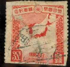
Japan, 1930, Scott 209, 25mm x 25mm

This stamp is a bit rougher than most of the others I have shown here, but I think still worth a look.

The map area of the stamp depicts the Japanese empire, which included Korea at the time of issue, highlighted in scarlet. Up in the north the portion of Sakhalin island which belonged to Japan also appears highlighted, depicting a state of affairs which also ended at the end of the second World War. On the banner at the top of the stamp is the chrysanthmum seal representing the Emperor, along with an inscription marking the second census taken of the empire’s subjects. More chrysanthemums appear along the left- and right-hand borders, dented at one point where the island of Taiwan puts in an appearance, and it is just barely possible to make out the Ryukyu Islands spread across the broad expanse of the China Sea. If Iwo Jima appears at all on this map, it would be as a small, insignificant red speck to the east.

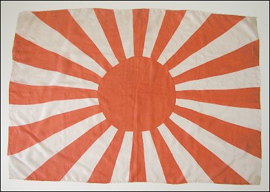
Two main elements of note here are the use of the color red and the 16-petals of the flower, both of which make up significant parts of the design of the Japanese battle flag during the war.

A quote from the Imperial Rescript on the 1889 Japanese Constitution governing the state at the time:

The Imperial Founder of Our House and Our other Imperial ancestors, by the help and support of the forefathers of Our subjects, laid the foundation of Our Empire upon a basis, which is to last forever. That this brilliant achievement embellishes the annals of Our country, is due to the glorious virtues of Our Sacred Imperial ancestors, and to the loyalty and bravery of Our subjects, their love of their country and their public spirit. Considering that Our subjects are the descendants of the loyal and good subjects of Our Imperial Ancestors, We doubt not but that Our subjects will be guided by Our views, and will sympathize with all Our endeavors, and that, harmoniously cooperating together, they will share with Us Our hope of making manifest the glory of Our country, both at home and abroad, and of securing forever the stability of the work bequeathed to Us by Our Imperial Ancestors.


90 miles

23 08 2008

Cuba, 1971, 40mm x 36mm

The first of these two stamps show how the Atlantic tropical storm tracks seem irresistibly drawn to the island of Cuba, where, fueled by the warm Gulf waters, some of them turn into the “great” hurricanes making landfall. We see the lines of latitude and longitude, along with the neighboring land masses, South Florida, the Yucatán, Jamaica, Hispaniola, and the Bahamas, but no labels on them.

Cuba, 1973, 40mm x 28mm

Here’s an issue from two years later, minus the hurricane paths but plus a few labels and some indications of depth and elevation. The Florida mainland and most of the other islands are cropped away here, and it appears that a few latitude lines chosen are different from the ones from before. The main thoroughfare from Pinar del Rio in the west to Santiago del Cuba in the east is highlighted in red with knots indicating the main population concentrations. Not shown: the Bay of Pigs, Guantánamo.


Not yet determined

13 08 2008

Pakistan, 1961, Scott 122, 39mm x 23mm

The text in the upper region in white reads Jammu & Kashmir (Final status not yet determined). And in the lower section of the stamp, next to the denomination, Junagarh & Manavadar which were once also disputed areas between India and Pakistan. The most prominent features shown in Pakistan are the waterways: the five rivers of the Punjab and River Ganges flowing through East Bengal.

The overprint in red marks the Lahore Stamp Exhibition of 1961, along with the national symbol of the Minar-e-Pakistan also depicted on the emblem of the city of Lahore.

As of the time of issue, the stamp was inaccurate as it postdates the accession of the two Gujarati seaside states to India in 1947, however the division into East Pakistan and West Pakistan which was the situation at the time. And, of course, the controversial status of Jammu and Kashmir which continues to this day.


The secret revealed

3 08 2008

I asked “What do these stamps have in common?”

The answer is: each one of them lacks the conventional orientation of North at the top, South at the bottom, like over 90% of all map stamps. The first two have a tilted compass rose, the last two have the lines of latitude and longitude showing the orientation, and for the one in the middle, you either need to look at a map on your own or you have to be familiar with Bavaria.

Perhaps I was being a bit too devious. What do you think?


Separation

24 07 2008

Tuvalu independence issue

Tuvalu, Scott 29, 1976, 28mm x 45mm

Here we have a map stamp which depicts almost pure ocean – only 300 square kilometers of the approximately 200000 shown here given over to solid ground, the rest of it being the South Pacific. Or, viewed another way, it depicts an actual map being torn in two, with the background the color of parchment rather than the usual ocean blue. The northern half of the map shows the mainly Micronesian Gilbert Islands, which is now part of Kiribati, the southern half shows the islands making up Tuvalu (formerly the Ellice Islands) with its Polynesian majority.

Why the split? To most people in the rest of the world, both Polynesians and Micronesians (and probably Melanesians too) would be lumped together in the category “people from the remote South Pacific” and that would suffice. Originally, the racial and classification was devised by the French ethnographer Jules-Sebastian-César Dumont d’Urville in the nineteenth century based on his observations. Recently, however, mitochondrial and Y chromosomal DNA analysis has been used to investigate how much of the similarities among these groups can be attributed to common ancestry and how much of the differences to isolation of populations.

At any rate, the process of separation between the two nations seems not to have been extremely acrimonious.


The route to Africa

20 07 2008

Liberia, Scott C43, 1942, 39mm x 24mm

Once again we have a stamp issue commemorating the air supply route from North America via South America to western Africa in the middle of World War II. Only three countries are depicted (the United States, Brazil, and the issuing country of Liberia). An outsized 4-engine transport plane (possibly a C-108 Flying Fortress) is shown alongside the coast-hugging path southward.

I am not sure that the business of transport is considered to have enough charisma to show up much on stamps nowadays, relatives to the most popular topicals.

Previously.