The route to Africa

20 07 2008

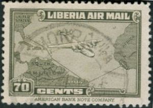
Liberia, Scott C43, 1942, 39mm x 24mm

Once again we have a stamp issue commemorating the air supply route from North America via South America to western Africa in the middle of World War II. Only three countries are depicted (the United States, Brazil, and the issuing country of Liberia). An outsized 4-engine transport plane (possibly a C-108 Flying Fortress) is shown alongside the coast-hugging path southward.

I am not sure that the business of transport is considered to have enough charisma to show up much on stamps nowadays, relatives to the most popular topicals.

Previously.


Time for a puzzle

9 07 2008

Yesterday I received my copies of the last two editions of the journal of the Cartophilatelic Society and was very happy to see the article I had written up. (It seems that my electronic address had gone astray somewhere along the way, so I had not been able to receive word the publication prior to this.) Here I present pictures of the five stamps which I used the illustrate the point of my piece. Incidentally, I notice that one of these stamps was also mentioned in a recent Marginalia column at the website.

Rather than just giving away the subject here, I thought I would try something different and set this up as a challenge for my readers. Can you see what the common theme is for all five of the issues depicted, which sets them apart from over 90% of all map stamps issued? It is something quite specific which any observant reader (or one who happens to have the April 2008 issue of the journal) would be able to state in very few words. When you have come up with the answer, put it into the comments on this post, and the first one with the correct interpretation will receive from me three map stamps from my accumulation.

Good luck!

West Germany, Scott 1009

Argentina, Scott 287

Australia, Scott 276

Jersey, Scott 183

Soviet Union, Scott 3180


The answer has been revealed


The rift

24 06 2008

Ascension stamp, Mid-Atlantic rift

Ascension, Scott 268, 1980, 36mm x 48mm

This stamp features two maps, one focusing on the topography of the Mid-Atlantic Ridge, the other on the ancient supercontinent known as Pangaea. Alfred Wegener came up with the theory of continental drift in the early part of the 20th century, long before the subsurface mechanism of tectonic plate motion were worked out. On the main map, the small island of Ascension, nearly unpopulated, appears here right in the middle of the action, slightly to the west of the ridge. Other features appear to the north and south: the archipelago of St. Peter and St. Paul Rocks, St. Helena island, and Tristan da Cunha island, amidst zones of sea floor faulting. On the inset map, of course, Ascension would be pretty much in the fault zone between between what became South America and what became Africa.

The occasion of the issue was the 150th anniversary of the Royal Geographical Society of Britain in 1830.


Understated cooperation

4 03 2008

brazil-1402Brazil, Scott 632, 1945, 37mm x 29mm
Here is another World War II commemorative masquerading as something celebrating international trade or something like that.

If one looks very closely at the destinations highlighted on this – Miami, Port [au] Prince, Puerto Rico, Trinidad, Georgetown, Belém, Fortaleza, Natal [Rio Grande do Norte], Ascencion, Accra, Khartoum, and Cairo – tiny little aircraft symbols oriented west to east can be seen. This represents the route of a major troop transport mission between the U. S. and the various war fronts:

[T]he huge Parnamirim field at Natal became the focal point in the Allied air transport system that ran west then north through Belém and the Guianas, across the Caribbean to Miami, and east over the Atlantic via Ascension Island and across Africa to the China-Burma-India theater.

Who knew? And who looking at this staid issue with its modest title and no especial emphasis on the battle front would have made the connection even back then?


Pacific coast settlement

20 02 2008

Chile, Scott 371, 1968, 39mm x 27mm
Map stamp, ChileThis stamp, which shows a portion of Chiloé Province in Chile with a sailing ship and more modern coastal vessel, commemorates the anniversaries of the founding of five towns in the 16th century. The map portion of the design shows mainly the outlines of the strait north of the province, indicating the position of just two of the five towns, and it would be somewhat hard to tell land from sea if it were not for the placement of the the ocean vessels. Wikipedia shows it to be an archipelago in the South Pacific.

Although it is not lauded in this stamp, one of the useful facts about this province is that it may be the original home of the domestic potato consumed around the world (though experts seem to disagree somewhat). It was mentioned in Charles Darwin’s Voyage of the Beagle, who described the inhabitants thus:

The inhabitants, like those of Tierra del Fuego, move about chiefly on the beach or in boats. Although with plenty to eat, the people are very poor: there is no demand for labour, and consequently the lower orders cannot scrape together money sufficient to purchase even the smallest luxuries. There is also a great deficiency of a circulating medium. I have seen a man bringing on his back a bag of charcoal, with which to buy some trifle, and another carrying a plank to exchange for a bottle of wine. Hence every tradesman must also be a merchant, and again sell the goods which he takes in exchange.


Shul on the equator

28 01 2008

Surinam 359
Suriname, Scott 359, 1968, Litho, 21mm x 36mm

The main design shows an antique map commemorating the founding of the first synagogue in the Western Hemisphere, in the settlement of Joden Savanne the Suriname River in the year 1685 of the common era. On the right hand side of the stamp, on the east side of the river, is the inscription “Ioods Dorp en Sinagoge” alongside a cluster of buildings which suggest that this is a rather small scale depiction. This region was hard to match up with an overall map of the country purely by eye, or even with the help of this historical reference:

In 1652, a new group of Jews arrived in Suriname, together with the Englishman Lord Willoughby, and settled on the Savannah, situated near the Cassipora creek.

My catalogue identifies the Hebrew inscription on the bottom as Joshua 24:2:

בְּעֵ֣בֶר הַנָּהָ֗ר יָשְׁב֤וּ

corresponding to a portion of this verse in English:

Joshua said to all the people, “This is what the LORD, the God of Israel, says: ‘Long ago your forefathers, including Terah the father of Abraham and Nahor, lived beyond the River and worshiped other gods.

in which the “River” is understood to be the Euphrates flowing through Mesopotamia (modern day Iraq), not of course the Suriname. The passage goes on to remind the Israelites about the original Covenant established by God and exhorts them to return to faithfulness.

There are Jews living in Suriname to this day, 350 years later, just a few degrees north of zero degrees latitude in South America. What must it have been like for their forebears to come to a country so different from the one they knew back then?


Apotheosis

5 01 2008


Image Hosted by ImageShack.us
By milkfish, shot with HP Scanjet G3010 at 2008-02-02
Scott 138, 1896 Lithograph, 34mm x 26 mm

The map depicts lines of communication and the border between Guayana Venezolano and Guayana Inglesa established earlier that century. Although he isn’t shown, Gen. Francisco Antonio Gabriel de Miranda is the subject of the inscription Apoteosis de Miranda that commemorates the 80th anniversary of his death in 1816. He was a revolutionary against the Spanish who died in prison, but whose campaign for independence was successfully fought by Bolívar and Sucre.

I am a little curious about the thinking of the designer, who evidently was content to illustrate the idea of apotheosisthe elevation or exaltation of a person to the rank of a god” using a rather plain-looking map with inscrutable lines drawn on it, in the space of something I can easily cover with my thumb. I would guess that his defense would be that the land is the chief glory of the one who had the vision for the land.

The Scott catalogue has a note about how the stamps in this series are frequently forged, and that the genuine articles have thin, semitransparent paper and thin, crackled gum. The one I have has both, along with a conspicuous gummed hinge mark on the back from some previous collector.

Of course, the nation of Venezuela appears in the news off and on these days over a hundred years later owing to the flamboyant behavior of their present leader and their key role in the petroleum economy. Oil was not discovered in Venezuela until nearly thirty years after this stamp was issued, transforming it into a wealthy and largely urbanized power in the region.