The secret revealed

3 08 2008

I asked “What do these stamps have in common?”

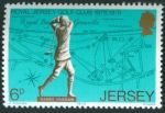
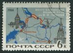
The answer is: each one of them lacks the conventional orientation of North at the top, South at the bottom, like over 90% of all map stamps. The first two have a tilted compass rose, the last two have the lines of latitude and longitude showing the orientation, and for the one in the middle, you either need to look at a map on your own or you have to be familiar with Bavaria.

Perhaps I was being a bit too devious. What do you think?


Outermost Europe

13 07 2008

Réunion island stamp

Réunion, Scott 65, 1907, 35mm x 21mm

This small spot of land is Réunion Island, an outermost region of the European Union and an overseas département of France. The map on this century-old issue is somewhat hemmed in by the heavily ornamented frame in a contrasting hue (here carmine red), especially the legend which does little to indicate that the island is a tiny speck in the midst of the Indian Ocean. The nearest landmass to this is the even smaller island of Mauritius (particularly famous in philatelic circles).

Here is a Space Shuttle image of the island which for me gives a good idea of its geographic isolation. These days, however, like most place in the world, it is possible to get onto the Internet from nearly every place on Réunion island for just about free.


Time for a puzzle

9 07 2008

Yesterday I received my copies of the last two editions of the journal of the Cartophilatelic Society and was very happy to see the article I had written up. (It seems that my electronic address had gone astray somewhere along the way, so I had not been able to receive word the publication prior to this.) Here I present pictures of the five stamps which I used the illustrate the point of my piece. Incidentally, I notice that one of these stamps was also mentioned in a recent Marginalia column at the website.

Rather than just giving away the subject here, I thought I would try something different and set this up as a challenge for my readers. Can you see what the common theme is for all five of the issues depicted, which sets them apart from over 90% of all map stamps issued? It is something quite specific which any observant reader (or one who happens to have the April 2008 issue of the journal) would be able to state in very few words. When you have come up with the answer, put it into the comments on this post, and the first one with the correct interpretation will receive from me three map stamps from my accumulation.

Good luck!

West Germany, Scott 1009

Argentina, Scott 287

Australia, Scott 276

Jersey, Scott 183

Soviet Union, Scott 3180


The answer has been revealed


The aeroplane age

7 05 2008

3 airmail stampsUnited States, Scott C10, 1927, 47mm x 20mm
United States, Scott C8-C9, 1926, 47mm x 20mm

Look! It’s Lindbergh’sSpirit of St. Louis” flying from New York to Paris under the helpful sculptural inscription Lindbergh Air Mail. And on the other two airmail stamps, pairs of mail biplanes on a collision course. In each one, forced perspective makes it appear as the final outcome for good or for ill should occur within one or two seconds, at most. These come from a time where air travel was still new and daring, an exciting human achievement the same way the early space age felt.

Unlike the simple outlines of the countries at the edges of the North Atlantic on the Lindbergh stamp, the biplane stamp maps emphasize the geographical features of the Lower 48, not the political outlines so much, except for the southern border in bold.


More mutton, along with triumph, disaster, and woe

22 02 2008

New Zealand stamp.
New Zealand, Scott 237, 1940, 37mm x 22mm
This lovely green and purple item depicts the route of the square-rigger SS Dunedin which carried the first shipment of frozen mutton from Port Chalmers, New Zealand to England on the 15th of February, 1882. Sailing across the south Pacific, she negotiated the passage around Cape Horn and the long voyage up the Atlantic to London, a total of 12030 (nautical?) miles, with its cargo refrigerated the whole time. (No word on what the cargo was for the long return voyage.) The continents are labeled boldly on the map, which has a frame celebrating the centennial of New Zealand in the year of issue.

Although the stamp celebrates peaceful commerce, it was issued at a time when the threat to merchant shipping was most perilous, with wolf packs of German U-Boats patrolling the sea lanes of the Atlantic. I can only imagine that the sender of a letter bearing this stamp would have had thoughts of the war in mind seeing this little image. And perhaps if that person were nautically-minded, thoughts might also have turned to the loss of the Dunedin less than a decade after this historic voyage, presumed wrecked on the rocks of Cape Horn.

This, to me, is a fine example of the idea I had when I gave this blog the name it has. Long stretches of time and huge expanses of the Earth combined with the big events of history, all are carried by a little bit of ink on a rectangle of perforated paper.



Ow

1 02 2008

Romania pistol shooting issue

Romania, Scott 1749, 1965, Litho, 43mm x 24mm

A grim-looking marsksman takes aim. The event is the 1965 European rapid-fire pistol competition and to set the venue there is an outline map of western Europe, all in white, except for the country of Romania in a sort of crimson stain.

But the dark blue crosshairs of the target appear to be superimposed over the Shetland islands in the North Sea as if the gunman had taken a particular exception to that part of Scotland, or perhaps forseeing the petroleum riches coming from there in the following decade. Although I will admit that the observer’s viewpoint is a bit warped, almost Cubist in a way. He is wearing what I take to be dark earth-toned hunting garb of some sort, contrasting with the white and the light blue ocean background, and is preparing to fire from a standing position.

This stamp is a so-called “cancelled to order” (CTO), sold to collectors in a used state, as seen by the pristine cancellation mark in the upper right. Many issues of the former Eastern bloc, as well as other countries seeking to make a profit on their stamp issues, used this method to ensure that what they were selling could never be used postally for legitimate mail.


The age of competitive flying

25 01 2008


Monaco, Scott 151, 1964, 37mm x 37mm diamond
This handsome engraved piece marks the 50th anniversary of the first airplane rally, showing the location of the European cities visited, although not the precise route. The design was based upon a postcard which depicted the monoplane flying over the harbor and the European cities picked out in the margin. The diamond format is unusual – Monaco is partial to unconventional stamp designs such as triangles as well.

This was a golden age of airplane racing, and despite the inscription on the stamp, it seems not the first major rally:

After Reims, a series of races were held across Europe—Paris to Rome; and circuits in France-Belgium and in England—pitting, for the most part, Andre Beaumont against Roland Garros. Here, too, Garros seemed to make more out of losing each time than Beaumont did winning. Garros finally won the races held in Monaco in August 1914, a year after the first Schneider Cup event, and then went on to be first to cross the Mediterranean.

Yes, this was the same Roland Garros of tennis French Open fame, remembered for his flying ace exploits in the first World War.


Acropolis rally

8 01 2008

Image Hosted by ImageShack.us
By milkfish, shot with HP Scanjet G3010 at 2008-02-02
Greece, Scott 1052, 1972, 33mm x 28mm

This stamps has the tortuous route of the Acropolis road rally depicted prominently in its design, with the twists and turns reflecting the mountainous topography of the Greek countryside contrasting with the plain light background. The race-style steering wheel making up the 0 of the 20 (for the number of years the race had been held) is a nice touch, I think. The map area is severely cropped at themargins and does not show Corfu, the eastern portion of Macedonia and Thrace, nor many of the islands (including Crete). I imagine this is in order to magnify the area of the map devoted to the race itself. But the section around Athens shows up well with the race route narrowing down to cross the isthmus in both directions. My impression of the triangular motive on the right hand part of the design is that it suggests a straight stretch of highway converging toward the horizon, but it could merely be decorative.

At the time this was issued, Greece was governed by a military junta, which I thought was odd for the place where democracy was invented. A couple of years later, it was thrown out in favor of a parliamentary form of government which has enjoyed free elections and a peaceful handover of power.

As car-crazed we are in the United States, it seems a little odd that we aren’t nearly as much into road rally type racing as they are in Europe. It’s got to be a lot more interesting than the kind of racing where they go around in oval for hours, I think. I really have no explanation for that.